
What’s New
Now that we have our trip planning app live, we will be regularly releasing new updates, improvements and fixes. Here you will a list of our latest releases and what’s included.

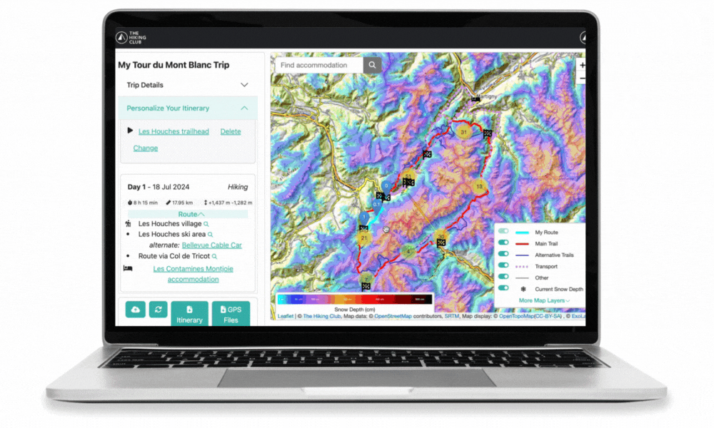
V1.11 Release: New snow layers on our map
This release focused on integrating two snow layers from ExoLabs. You can toggle them on from the key in the bottom right-hand corner of the map right now! Read more about these snow layers in our partnership announcement here, or see them in action as part of our 2024 trail update program for;

V1.10 Release: Itinerary updates, Route images, and a New video series
This release focused on improving the format and printability of the itinerary document, adding new route images to the Walker’s Haute Route and Tour of Monte Rosa, and, creating a new video series on how to use the app.
For those who created an itinerary (or used a template) that had the same start and end location (circular trails like TMB), you weren’t able to change your day 1 route. Each time you tried to add a day 1 route waypoint, it would appear on the map labeled as 0 and could not be moved or removed. The problem has been identified and resolved in this release.
If someone had a rest day at the start or end of their itinerary, the itinerary report wouldn’t generate. We’ve now updated the code to allow the itinerary report to be viewed when rest days are at the start and end.
When we released the itinerary report in January, we labeled it a ‘Beta’ version to highlight that we still wanted to improve it. The main code changes in this release were focused on making valuable improvements. There was lots of little things, but the bigger ones you’ll likely notice are;
Printable itinerary report: Printing the previous version of the itinerary report was a problem with the formatting appearing bloated. In this release, we integrated a pdf builder into our itinerary report along with some other customisations to improve how the document would display. If you select the print icon now, it will download a pdf of your itinerary report which you can then print, email to your hiking group, and/or store on your phone to refer to when on the trail.
New total trail elevation profile: A new ‘total trail’ elevation profile was created for the itinerary report that includes where transport is planned (highlighted in orange). This elevation profile is the same format that we had used for the daily profiles when we launched the itinerary report, so we have alignment across the whole document now. Just a reminder, the data in the elevation profile is from open sources rather than our verified trail statistics and includes planned transport legs; therefore, you won’t be able to directly reconcile it to the trail statistics breakdown displayed in the tables above. The open-source data is accurate enough to provide a good visual representation of the elevation profile for each journey/day, however, if looking at it in fine detail, please disregard little spikes you may see along otherwise linear sections - these types of errors are why we have spent the time building our own database of trail statistics so our customers can plan with confidence in our app.
Improved daily elevation profiles: We took off the restriction of the vertical axis (y-axis) of the elevation profiles always starting at zero, and instead allowed it to ‘float’. This means that the y-axis low point is dynamically set to be a few hundred meters below the minimum elevation point for each elevation profile, and high point a few hundred meters above. By making this change, the elevation profiles will appear steeper, which is a more realistic view of the trail gradient across each day/journey, given none of our current trails are close to 0/sea-level!

See new video here explaining the itinerary document
We first did the Walker’s Haute Route in 2017 and Tour of Monte Rosa the following year. Other than one covid impacted year, we’ve been back on these trails exploring new routes, enjoying our favourites and seeing how they change in different seasons and weather conditions. As part of this release, we went through our overwhelming library of images along the Walker’s Haute Route and Tour of Monte Rosa to add more to the map. To see these images, either;
Click on a red or blue trail, and a pop-up will appear with images and descriptions; or
If you want to see images of the route you have already planned on the map, click on the little magnifying glass at the end of any section name in the ‘Route’ drop-down on any day in the left-hand side panel - you the map will zoom to the area of the trail where the route is, highlight it, and show you the images and a description.

See new video here explaining how to find descriptions and images of the trails
Since November, we have we have made a bunch of app updates, consisting of both display and functional improvements. To ensure you are aware of how to use all the nifty features built into the app, we've created a new ‘How to use The Hiking Club trip planning app’ YouTube series. Everything from how to create an itinerary from scratch, how to add a rest day, how to add transport, to how to find route descriptions and images.

See the new video series here
We currently have 15 videos in the series, but if you have any suggestions for new videos, please let us know!
For those who would prefer to read step-by-step instructions, tips, and tricks, you can still find our guide here

V1.9 Release: Automatic access to app upon purchase
Before this update, someone in our team would manually grant customers access to the app. If our team were awake and had access to the internet, we would race to complete the step before the new customer tried to enter the app. If we were asleep or out hiking…it could take 6+ hours to complete! After frustrating some of our new customers over the last few months (sorry!), we dedicated release 1.9 to making sure you can get instant access to the app!

V1.8 Release: Making it easier to start planning and review your itinerary
This big release gives hikers a head start on their planning with our sample itinerary library, a personalized itinerary report/document, and some minor interface changes.
As we gather feedback and add new features, we’ll move a few things around in the app so it’s easier to use and find what you’re looking for. A summary of key changes in this release include;
‘My Itineraries’ page (landing page upon login)
Simplified information in the welcome message
The ‘See sample itineraries’ drop-down was added for users to access our itinerary library.
A ‘Purchase App Access’ button has been added for those entering the app without a purchase.
Key details are now displayed for each itinerary listed to make it easier to find the one you want
A countdown timer has been added to build excitement!

Map page
Access to the GPS map files can now be found on this page at the bottom of the left-hand panel
A new button to access the new Itinerary document has been added beside it

When we started The Hiking Club, we offered a range of itinerary templates that would come with a detailed document and GPS map file aligned to the plan. They were popular but nearly all our customers would request changes.
We have now come full circle and can offer our customers a range of sample itineraries again! This time they are loaded into the app so our users can edit/modify them as much as they like to align them with their route, accommodation and transport preferences!
We have between 6 and 11 itineraries for each trail. They are mostly differentiated by the number of hiking days, however, we’ve added some specific samples for those that want to camping or complete the trail in a shorter time by taking transport to skip ahead.
Click to expand. Our new sample itinerary library available with any self-guided hiking package.
This one was a biggie. Along with our GPS map files, the itinerary document is a key output you receive when you plan your trip with The Hiking Club.
When adding this feature to the app, we maintained the same structure/format as the itinerary reports we’d been using for the last 5 years. The document reveals all of the key information specific to the route that you’ve been interacting with on the map (and possibly some you didn’t know was there!). Not only does it put all the details about your journey in a more legible format to review and share with your hiking buddies, it also allows you to confirm that the route you have chosen is as intended. For example, if you intend to catch a bus from one end of the line to the other but see a hiking section in the middle, it means you need to add another route pin to your map to ensure the network chooses the bus the entire way.
We did make a couple of enhancements to the elevation profiles - most notably, they now use elevation data from thousands of GPS points along your route to be more accurate and include the time you’re planning to spend on transport during your hiking journey.
Click to expand. Our new itinerary doc available with any self-guided hiking package.
Although we are confident in the trail stats being presented and the alignment between the map and itinerary document, we have labeled the Itinerary as a ‘Beta’ version due to a few outstanding items we couldn’t resolve in time for this release. The most notable changes we will be making by the end of February include;
The document doesn’t print well. We know many hikers like to take this document with them, so we want to ensure it is formatted in a way that prints efficiently. If you’d like to print the document now, I recommend reducing the size to 60% in your printing settings for the best result.
The overall elevation profile doesn’t show where transport is being taken, even though it is included in the chart.
The summary map of the route doesn’t display correctly on the page when printing.
There are a couple of bugs preventing the full document from generating in some cases too;
If you have previously done a ‘free pick’ of your start and/or finish location on the map instead of selecting a flag or accommodation point as these locations. You can tell if you have this issue as your start location will be listed as ‘0’ in the left-hand side panel, and your finish location will be the number of your last day. You can resolve this issue by selecting a new start and finish location (either a free pick, a flag, or an accommodation location).
If you have added rest days at the end of your itinerary. The document expects the last day to be a hiking day at the moment.
Although we have done a lot of testing, there are too many itineraries in then app now to look at everything. If you find any issues with your itinerary, please contact us so we can review what might be the cause.

V1.7 Release: See more on the Map
This release is focused on highlighting more information on the map that will support your daily planning and preparation, as well as making it easier to find properties or accommodation locations you have in mind.
Refresh fix - Upon entering the app, you no longer need to refresh the page before creating an itinerary or seeing any sample itineraries assigned to you.
Hidden itinerary fix - we’ve removed the restrictions in the app that were preventing some users from seeing itineraries they had previously created.
An accommodation search bar has been added to quickly find a property or location with accommodation on the map. Here is some more information on how it has been populated and works;
The search bar is being populated from the list of accommodation in our database, not Google maps.
A maximum of 8 properties/locations will be shown in the auto-complete listing
Campgrounds all have the word ‘campground’ and permitted bivouac/wild camping locations all have the word ‘bivouac’ in their name - so you can search these words to see options but remember only 8 will show in the listing so we’d recommend also searching around the map to visually spot the campground and bivouac icons too.
You can select an accommodation by pressing enter, or clicking on a property in the auto-complete list once you’ve started typing. If there is still more than one property in the auto-complete list when you press enter, it will take the top entry as your search query and find it on the map.
Upon selecting a search entry, the map will zoom to the accommodation location and where you have chosen a property, the pop up will be opened.
We’ve been gathering and maintaining a database of points of interest along the trails we support for over 5 years now. Previously, we’d complete a refresh of these points of interest by May/June each year and embed them in hikers final GPS map file for the upcoming hiking season. With our new app, we have transitioned these points of interest onto the map so you can use them for your daily planning and preparation well ahead of hitting the trail. These points of interest include:
Water re-fill points
Toilets
Food (Bakery, cafe, supermarket, restaurants)
Transport onboard/offboard points (bus stop, gondola stations, etc)
Laundry
ATM
Special notes
We will continue to refresh these points by May/June each year, including embedding the new transport schedules into the onboard/offboard transport points for the upcoming hiking season. App users can then download their final map files from the app, which will include all the points of interest and information for offline use when navigating.
One of our goals is to have a way for hikers to easily report back changes to these points of interest or suggest new ones they find that would benefit others in the hiking community. Stay tuned for more information on this feature.
To see them, click ‘More Map Layers’ in the key located at the bottom right-hand corner of the map, and an accordion will expand to show the new points of interest that can be shown on the map by ‘toggling’ them on

Clicking was so yesterday! Included in this release is a new ‘hover’ feature which was one of the most popular requests by our app users.
Now you can go around the map and hover over any accommodation icon to see its name. If you want to see more, then click the icon to reveal more details! This feature has also been applied to the new Points of Interest to reveal their name and (sometimes) a very short description.

A ‘Reset Itinerary’ button has been added to the left-hand panel on the map. Clicking it will remove all waypoints on the map so you can start creating your route again.
Upon selecting the button, you’ll receive a warning box to confirm you want to remove all waypoints because once you do, they are gone!
When you reset an itinerary, all of the ‘trip details’ will remain the same (start date, number of nights, etc) and you’ll stay on the map page. In our last update, we made all of the ‘trip details’ editable, so you can change these at any time.
We hope this change means you only need to create a new itinerary if you are genuinely considering an alternative plan for the trail, not because you’ve made some errors and want to start again.
Updated Trip Details labels:
Number of days now refers to both hiking and rest days
Day, month and year has been added to the date labels so you know how to update them if editing directly in the date box
As part of the Points of Interest update, a new accordion was implemented for the map key so we can list more information that can be toggled on/off without permanently taking over more real estate on the map.

v1.6 RELEASE: Now EDIt, Everything…
This release is focused on enabling you to edit all aspects of your trip while you are in the “planning” phase of creating your itinerary.
- The start date issue has been fixed for those in the Americas. The date you pick when creating a new itinerary will be the date shown in the map. A special shout out to AV1 hiker and developer Joel F for identifying the cause and suggesting a fix!
Now you can edit everything in the “Trip Details” section
You can now change the start date of any itinerary
You can now change the hiking speed of any itinerary
You can now change the description/name of any itinerary

Change your number of hiking days planned easily within the Trip Details tab
The number of days is a really important attribute in the itinerary-building process, so making it editable was a big change. For those interested, here are the different scenarios and how it will work:
If you have set your finish location and increase the number of days:
Your finish location remains in the same position but becomes the waypoint for the new number of days
For example, if you change from a 10 to 12-day itinerary, your finish location remains in the same position but is now labeled as day 12 rather than day 10
You have not set your finish location and increase the number of days:
You now have more accommodation waypoints to add before your finish location
For example, if you had placed the first 9 accommodation waypoints and change from a 10 to 12-day itinerary, you need to select day 10 and day 11 accommodation waypoints on the map before adding your day 12 finish location
You have set your finish location and decrease the number of days:
All accommodation and route waypoints greater than the new number of days you’ve set for your itinerary will be deleted
For example, if you change from a 12 to 10-day itinerary, your day 12 finish location and route waypoints, and, your day 11 accommodation and route waypoints will be removed
You have not set your finish location and decrease the number of days:
If the new number of days for an itinerary is the same as the highest accommodation waypoint that has been placed on the map, that accommodation waypoint will become the new finish location on the map
If the new number of days for an itinerary is greater than the highest accommodation waypoint that has been placed on the map, no route or accommodation waypoints are deleted.
Although we tested it extensively, please do let us know if you have any issues when shortening or extending your itinerary length.
You can set and change your start and finish location to be;
A checkered flag (our recommended start/finish locations along the trail)
Any accommodation location
Pick on map (existing functionality).
We highly recommend setting your start and finish locations as checkered flags or accommodation locations to ensure your trail stats are accurate! You can toggle off the checkered flags if you don't want to see them while planning the rest of your itinerary.
You can delete your start (if no accommodation has been selected) and finish location, if you would prefer to clear them from the map rather than using the above functions to change their location
We've changed the transport color from green to purple to make it easier for people to see
We've increased the 'click' area around the routes and accommodation to be 400% larger to make them easier to select.
The transport and 'other' routes will be 'toggled on' when you open the map. This is to ensure everyone knows they are available on the map. If it makes the map too busy for you, simply toggle them off.
Improve app load speed by reducing map size by ~75%
When you (or the app) refreshes the page, it will stay on the map rather than pushing you back to the 'my itineraries' page

v1.5 RELEASE: Daily breakdown
This release is focused on revealing more of the route and transport content we have in the app and allowing rest (non-hiking) days to be added into itineraries.

You can now change the underlying map to a version with contour lines to further familiarise yourself with the route
See your daily itinerary broken down by routes and transport
Alternative transport options are suggested within your daily breakdown i.e Gondola, Bus, Train. Select this transport (by either dragging your route line or by dropping a pin on your route and dragging it to the transport route) to shorten your hiking day stats
Add rest days to your itinerary. Simply choose the accommodation for every night you wish to stay there i.e Night 2, 3, 4.

V1.4 RELEASE: HELLO WORLD
It’s here. The world’s first, purpose-built app for planning and navigating multi-day trails.
