
Since moving to Switzerland in 2016, Jonas’ love for the mountains has blossomed. He’s hiked and run through forests, hills, and mountains, completing multi-day tours like the Tour du Mont Blanc and Tour du Monte Rosa. Venturing into high-altitude mountaineering, he’s conquered over 10 of the Alps' 4,000-meter peaks. In trail running, he’s become one of the fastest from my low-altitude homeland, the Netherlands, participating in races like Sierre-Zinal and OCC. As an International Mountain Leader, he guides and shares his love for the mountains with others.

Jonas de Jong (Instagram)
tour du mont blanc TRIP SUMMARY

Screenshot of Jonas’ 7 day Tour du Mont Blanc itinerary summary from our trip planning app

In 2020, I tackled the full 160km Tour du Mont Blanc (TMB) over 7 days, and it marked the beginning of a new chapter in my life. The renowned TMB crosses through three countries, and I commenced my journey in Champex, Switzerland. By the end of the week, I returned as a changed person. It delivered everything I could have hoped for, and more. Incredible food, breathtaking views, fascinating encounters, achieving a personal challenge, and plenty of running. What more could you ask for?
You can opt for some variations, as I did twice, but the main route remains the same, circling the Massif du Mont Blanc, essentially the mountain and its entire range. Each day, you can rest at comfortable huts or hotels, making it the perfect blend of exertion, good food, and a refreshing shower at day's end.
I chose to run the route clockwise (not the standard way) as I thought it would be nice to encounter more different people, rather than the same ones. It’s a personal choice and it does not matter much in terms of route. So let’s jump into my day-by-day trip report!
Day 1 - August 30: Champex-Lac🇨🇭 > Auberge la Peule🇨🇭
Distance: 21km /
Elevation change: ⬆️ 1,200m / ⬇️ 600m /

Day 1 elevation profile of my route, taken from The Hiking Club trip planning app.
When you plan a multi-day run in August, you'd expect it to be a summer adventure: blue skies, basking in the sun, getting a nice tan and having no worries about the weather. However, I ended up encountering plenty of snow!
As a city boy from the low countries of the Netherlands, sometimes below sea level, I had a lot to learn before I could consider myself an experienced ultrarunner in the Alps. The first thing to consider is safety, and that starts with keeping an eye on the weather.
I highly recommend checking the current snow levels on The Hiking Club app before you go to make sure you know what you're getting into; it's a fantastic new feature! Unfortunately, it wasn't available when I ran, so the rain at Champex turned into snow as I gained altitude toward the Val Ferret. By the time I reached my first night's shelter at Auberge La Peule, there were already a few centimeters of snow, and when I woke up the next morning, it felt like a winter adventure!
Today’s route is sometimes skipped by other hikers, as there is an easy bus and some stretches along the road. However, I feel the Swiss Val Ferret is beautiful in itself and to me, it was a special start.

Waking up to fresh snow at Alpage La Peule on August 30th
DAY 2 - August 31: La Peule🇨🇭 > Courmayeur 🇮🇹
Distance: 26km /
Elevation change: ⬆️ 1100m / ⬇️ 2000m
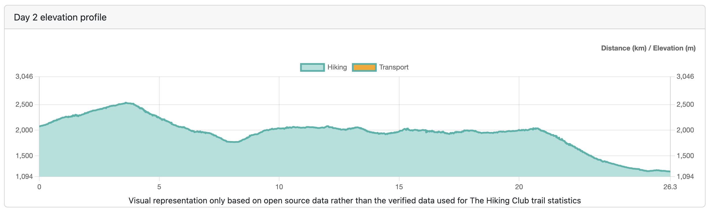
Day 2 elevation profile of my route, taken from The Hiking Club trip planning app.
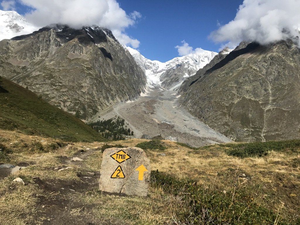
Today, I encountered plenty of snow on my way to the highest point of the entire loop, the Grand Col Ferret at 2,537m. I set out early to ensure I had plenty of time, another safety precaution. I also informed the hut wardens of my destination, packed enough food, and water, and ensured my batteries were fully charged, in addition to carrying a paper map. Nowadays, you can also download GPS files for your route from the Hiking Club app to further enhance your safety and route finding. This is crucial in case of unexpected snow because the path is not always easy to see.

The first view of Italy, after crossing the Grand Col Ferret, not as green as expected
After crossing the col, the route continues into Italy via the famous Balcon Nord, which, in good weather, offers the first glimpse of Mont Blanc. Before reaching Courmayeur, where I concluded the day, I passed no fewer than three Italian huts. They provided hearty mountain meals such as polenta or a much-needed first espresso.
This leg of the journey is particularly beautiful, but after the long descent into Courmayeur, I was grateful to sit down for pizza and enjoy the luxury of a hotel room and a hot shower!

The Balcon Nord, on my way to Rifugio Bonatti, the Mont Blanc is not showing herself just yet.
DAY 3 - September 1: Courmayeur 🇮🇹 > Refuge des Mottets 🇫🇷
Distance: 25km /
Elevation change: ⬆️ 1,900m / ⬇️ 1,200m

Day 3 elevation profile of my route, taken from The Hiking Club trip planning app.
Waking up in Italy brought clear blue skies and the promise of a great day ahead. Feeling refreshed after an Italian breakfast, I left Courmayeur in high spirits, making my way slowly up to another balcony trail. This time, it was Val Veny revealing its beauty to me. I made a mental note to return here in winter; the ski slopes I crossed must offer an amazing experience as well!
Running up and out of Courmayeur stone markers show the way
The sight of those immense glaciers, so close yet so far away on the other side of the valley, was breathtaking. I could only imagine the mountaineers making their way up now, either by the large cable car from Courmayeur all the way to Pointe Helbronner or on foot, of course.
After crossing the first of the two big cols of the day, I descended to Rifugio Elisabetta, where they made me an amazing Italian sandwich for the second part of my day. Unfortunately, I had to leave Italy behind and spend the night as planned in France. First, I reached the highest point of the day, Col de la Seigne, just above 2500m, before descending to my destination, which I could already see from the top.
Day 4 - September 2: Refuge des Mottets 🇫🇷 > Les Contamines 🇫🇷
Distance: 21km /
Elevation change: ⬆️ 1,000m / ⬇️ 1,700m /

Day 4 elevation profile of my route, taken from The Hiking Club trip planning app.
Last night, I noticed that there were more people for dinner than there were beds in the rooms and dorms. Taking a short evening stroll, I saw several people had decided to bivouac a short distance away from the hut. This seemed like a great option for next time, as you get the benefit of good and ample food, but the privacy and beauty of a night under the stars (check out The Hiking Club app to find permitted bivouac locations).
Today brought more snow, although I didn't know that when I left the refuge. I decided to take the Col des Fours variant, that would involve some more climbing but fewer kilometers, and then meet up with the main trail near Col de la Croix du Bonhomme. Here, the route crosses for a time with the long-distance hiking trail GR5, of which the Alpine section starts in my hometown, Lausanne, Switzerland. I was increasingly lucky with the weather, and the view from the top was literally the high point of my day. The way down towards Les Contamines was still long, and my feet and knees started to ache by the time I made it to my bed 1,500 meters lower.
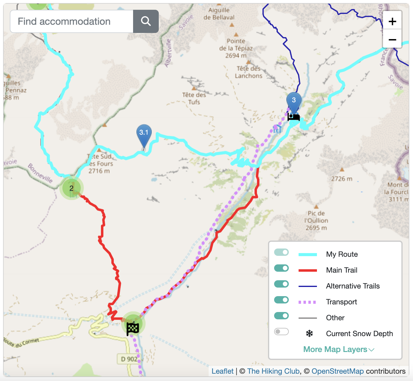
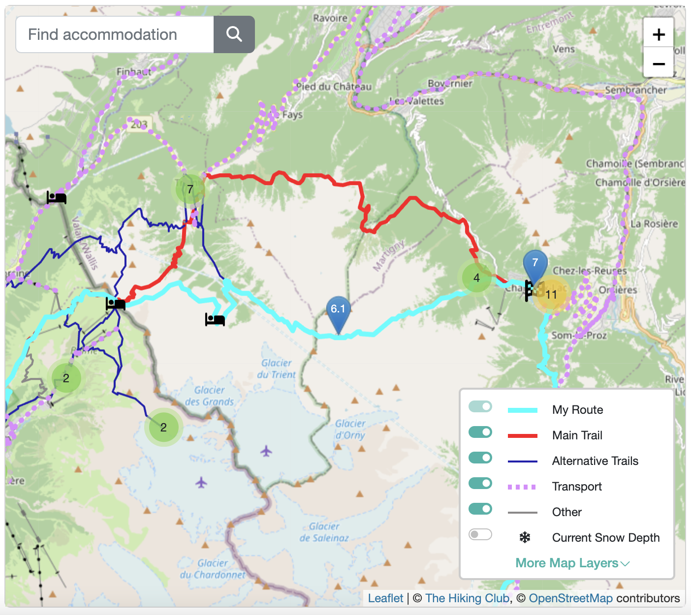
The Col des Fours variant diverts from the main trail (red line) near Refuge des Mottets (East) and near Col de la Croix du Bonhomme (West), as shown in The Hiking Club app.
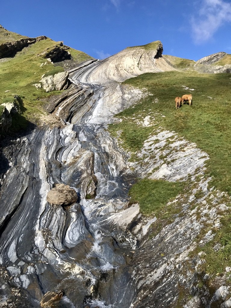
Special rock formations, just after the Refuge des Mottets, which piqued my interest for my later study to become an International Mountain Leader

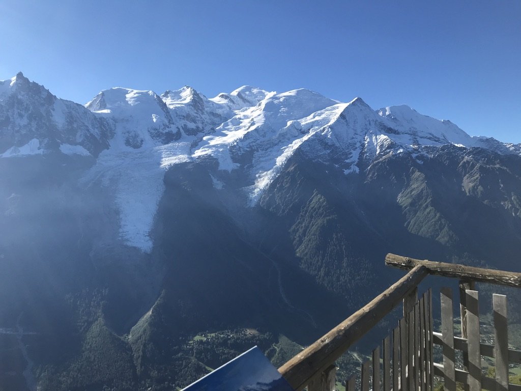
Finally, Mont Blanc as seen from the Tete Nord des Fours
Day 5 - September 3: Les Contamines 🇫🇷 > Les Houches 🇫🇷
Distance: 18km /
Elevation change: ⬆️ 900m / ⬇️ 1,100m /

Day 5 elevation profile of my route, taken from The Hiking Club trip planning app.
Not the most exciting day on the map, but one steeped in history and good stories! It's such a beautiful valley to walk through after braving the higher valleys and cols for the previous days. Rounding the massif on the western side brought me within reaching distance of Chamonix, the mountain capital of the Alps, which, maybe surprisingly, you don’t actually cross on this route.
This section between Les Contamines and Les Houches is where the UTMB (the ultra-famous 100-miler trail running race) starts to heat up every year. It’s still daylight when the best trail runners pass through here, and you'll feel like one of them as you run down this stretch!
The highest point of this day is only at 1,670 meters and is called Col de Voza. Here, you cross some chairlifts and the train line to Nid d’Aigle, the Eagles Nest. This train brings many mountaineers halfway up the Mont Blanc massif in the summer. You might see some of them as you run along the track. They will venture to the highest part of Europe, but I went further down to the villages below.

Plenty of water refill options along the trail, find them in The Hiking Club map, they are all there!
Day 6 - September 4: Les Houches 🇫🇷 > Montroc 🇫🇷
Distance: 26km /
Elevation change: ⬆️ 2,200m / ⬇️ 1,900m /

Day 6 elevation profile of my route, taken from The Hiking Club trip planning app.
After a shorter day yesterday, today was a big one, and oh so beautiful. It started straight out of the village of Les Houches, through the forest, past a Jesus statue overlooking the valley below, all the way up above the treeline. It’s such a special experience to see how far your legs can take you, and there's no better way than to run up a mountain.
The view on Mont Blanc from the Refuge de Bellachat at 2,152m on the way to Le Brevent
Once you’ve climbed 1500 meters vertically, you'll reach Le Brevent, which is usually busy on a good day with plenty of tourists who come up on the cable car. As you are now on a south-facing slope, this area is called Grand Balcon Sud, offering another fantastic view of the Mont Blanc massif for a good part of the day.
On the long descent, I extended my day slightly by passing by Lac Blanc. This way, I also avoided the ladders, which wouldn’t necessarily scare me, but I don’t enjoy waiting so much. So, if you also prefer to keep on running, divert off the main trail up to Lac Blanc, enjoy lunch by the shores or at the mountain restaurant, before making your way through fields of blueberries down to Montroc. In September, these berries attract many mountain goats filling their bellies before winter.

Avoid the Aiguillette d'Argentiere ladders by taking the alternative route (see pin 5.2) rather than the main trail (red line), as shown in The Hiking Club app.
Lac Blanc, a great place for a rest stop before hitting the descent.
Day 7 - September 4: Montroc 🇫🇷 > Champex-Lac 🇨🇭
Distance: 26km /
Elevation change: ⬆️ 2,300m / ⬇️ 2,200m /

Day 7 elevation profile of my route, taken from The Hiking Club trip planning app.
Not for the faint-hearted, this final day could be split into two with a stopover in Trient, depending on your schedule. It all starts with a nice 700m climb up to Col de Possettes to warm up the legs. Then, you'll follow some flowing trails up and over the Col de Balme, crossing back into Switzerland. This is a fantastic section to utilize all those skills you gained during the week and let it go because the end is near.

Looking back to yesterday’s descent and Mont Blanc from the Aiguillette des Posettes
I enjoyed all the cols this day brought, but I definitely felt the tiredness in my legs when I started the climb towards the Fenetre d’Arpetre (another variant). I highly recommend this stretch for its wildness; it's very beautiful and away from the crowds. The Trient Glacier on your right is another famous one that has been rapidly declining for decades. Some 50 years ago, ice was still harvested here to chill beverages on terraces as far away as Paris, Lyon, and Marseille! You can still see the infrastructure of little 'bisses' or mountain canals, which were created to transport ice and water to the villages. Nowadays, it makes for an easy, flowing running path to bring you back to Champex-Lac!
The Fenetre d’Arpetre (via Refuge les grands) variant diverts the main trail from Col de Balme (West) and near Champex-Lac (East), as shown in The Hiking Club app.
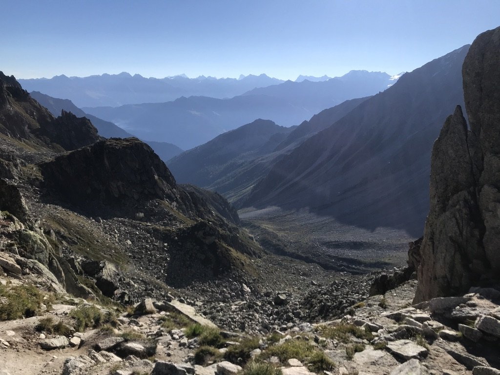
The wild valley of Arpette from the Col
Author and photography: Jonas de Jong. You can follow Jonas on Instagram to see more of his mountain adventures.