

easily plan your multi-day hike
The first purpose-built, all-in-one planning app for multi-day hikers to create a personalized itinerary, organize accommodation, and confidently navigate their trip.
Planning a multi-day hike used to be difficult.
It involved extensive research - internet searches, map reviews, guidebooks and asking questions on forums - to gather up-to-date and relevant information. All these details were then consolidated, along with calculations and time estimates, to make sure the overall plan was achievable. Then came the accommodation booking part. Finding fully booked locations along your chain of dates would trigger a rejuggle of your entire itinerary. Frustating.
Our research shows that the planning process is the most frustrating part and takes hikers an average of 2-4 weeks to complete.
We’ve built a new planning app to turn the planning process from painful, to enjoyable!
ACCURATE trail data at your fingertips
Automatically calculate hiking stats
Throw away your spreadsheet. Choose your timing estimate - walk, hike, or fastpack - to create an itinerary at your pace. Your estimated time, distance, and elevation change are automatically calculated and displayed with every route and transport decision.
Create an itinerary in one sitting
Use our extensive trail database to select your route and accommodation directly on the map. Easily visualise your route, broken down day by day, to prepare each day of your trip.
FULLY PERSONALISE YOUR ITINERARY
ADD TRANSPORTATION TO YOUR PLAN
Need to shorten your itinerary? Easily select transport options (gondola, bus, train) to see the impact to your daily hiking stats. All transport details including 2024 schedules and costs are included in your final GPS map.
Door to door trail stats
Select your accommodation, campground or permitted bivouac location to get accurate daily hiking stats. Know ahead of time if the location is off the main hiking routes. No-one wants surprise mileage at the end of a long day on the trail!
Discover different route options
Learn about main v. alternative routes including images, description, difficulty and impact to hiking stats.
CHOOSE START/END LOCATION
Select a trailhead to start/end your trip to suit your transport, route or time preference.
USE OUR SAMPLE ITINERARIES TO GET STARTED
CHOOSE FROM SAMPLE ITINERARY DATABASE
Explore our range of sample itineraries to get a sense for what itinerary is best for you - fastpacker or wanderer, main trail or variants, with or without transport etc.
CREATE DIFFERENT ITINERARY VERSIONS
Play around with different scenarios such as start/end location, direction, hiking speed, route, number of days, transport etc. The options are endless!
DOWNLOADABLE TRIP ITINERARY
Download and/or print your daily hiking plan which includes your distance, elevation profile, estimated hiking time and information on your chosen route.
DAILY BREAKDOWN OF HIKING STATS
Plan each day with a detailed breakdown by section of your hiking route. See elevation profiles and identify transport options if you decide to skip ahead while on the trail.
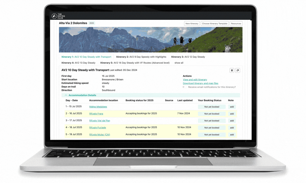
EASILY BOOK AND ORGANIZE YOUR ACCOMMODATION
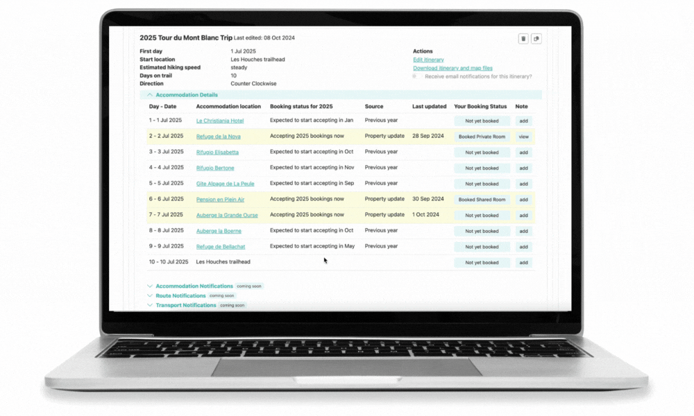
SEE ACCOMMODATION BOOKING STATUS
Don’t miss out on your preferred accommodation by seeing their current booking status or when they expect to accept bookings.
KEEP A RECORD OF YOUR BOOKINGS
Add your booking details to each night including room type, deposit details to keep everything in one place.
SECURE BEDS IN POPULAR MOUNTAIN HUTS
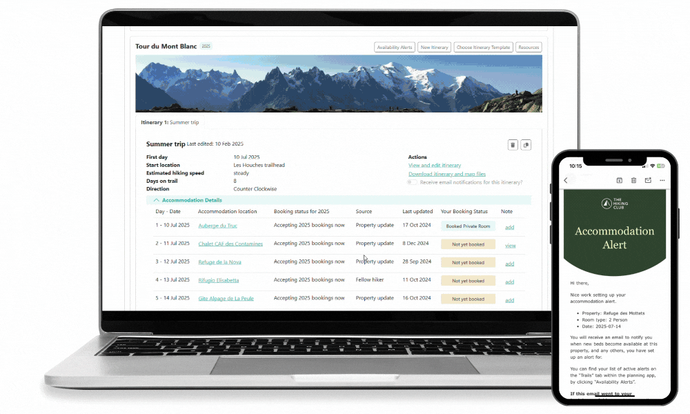
email alerts when beds become available
Set email alerts to be notified when: (1) properties start accepting online bookings for the season, and (2) when they list new beds online for different room types. Learn more about alerts.
SEE REAL-TIME AVAILABILITY
For the huts with online booking systems, see their real-time hut availability for the upcoming season. See list of 100+ huts with real-time availability available in our app here.
ACCESS LATEST SNOW ESTIMATES ON YOUR ROUTE
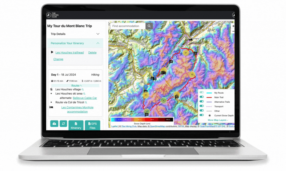
CURRENT SNOW DEPTH
Check the snow conditions prior to your hike to understand if there is snow and its expected depth along your route. You can decide to alter your route to an alternative route with no/less snow or skip ahead with transport.
48 HOUR SNOW FORECAST
Understand where and how much snow is expected to fall along the trail for informed hiking decisions. Learn more about our partnership with ExoLab.
RESOURCE LIBRARY TO PLAN EVERY ASPECT OF YOUR TRIP
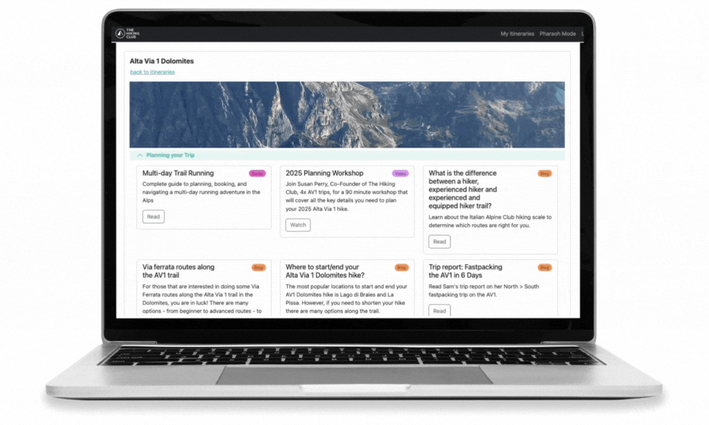
ACCESS webinars and workshops
Watch recorded events from our trail experts and specialised partners to get detailed tips and tricks on planning and preparing for your multi-day trip
50+ detailed blog posts
Explore our library of blog posts that cover topics from - best time to hike, how to get to/from the trail, best weather apps, baggage transfer options, emergency service numbers and more.
Feel confident navigating your route
Once you’ve finalised your route, download gpx and kml files to use with your preferred navigation app (i.e Organic Maps). Alternative/variant routes are also visible in case you’d like to change your plan while on the trail. You’ll also receive a comprehensive set of location markers to help you prepare for each day on the trail, including transport locations, water refill, toilet, food/supermarkets, ATMs.