Congratulations to the hundreds of hikers that have completed the trail in 2019 and can proudly add the Walker’s Haute Route to their list of life accomplishments.
For those about to start the trail, I‘ve just finished an August trail update which has a specific focus on the rockfall zone near Pas de Chevres.
Before I go through the August trail update, there are 3 insights from 2019 I’d like to share:
No one ever said it would be easy
The challenging terrain, constant elevation changes, high altitudes, snow (for those who hiked earlier in the season!) and exposure to the elements, means that every day is earned and should be celebrated. A good base-level of fitness will ensure it is possible, but determination and resilience will be required to reach the Matterhorn. It’s a good thing multi-day hikers are tough!
The support of hiking buddies cannot be underestimated
Even if not a single word of encouragement is offered, the distraction of conversation and seeing others struggle or achieve tough sections on the trail helps hikers realise they are not alone and what is possible. Whether you bring them with you or find them along the way, hiking buddies are a source of strength that will become part of the memory as much as the beautiful landscapes.
Everyone experiences the trail differently
I’ve loved being in touch with many of you throughout your Haute Route hike. Due to the amount of snow this year, changing terrain at Pas de Chevres and overall difficulty of the trail, many of my conversations have been about whether different sections would take a hiker too far out of their comfort zone. The right decision for one hiker is not necessarily the same for others. Making it safely to Zermatt with a greater love and appreciation for the outdoors is what really matters.
Thank you to everyone that shared your experiences and trail updates with me throughout your journey. I’ve found the only problem with being a virtual hiking guide is that I don’t get a chance to meet and have some fun on the trail with all of you :p
Walker’s Haute Route Trail Conditions
Given the amount of snow still on the trail in July, the last update was focused on where the most difficult spots were. To supplement the information shared with me by hikers on the trail during the end of June/start of July, I completed the section from Les Ruinettes to Arolla on the 11th - 12th of July to check it out first hand. This was around the time that more hikers started crossing this area with many reporting 10+ hour days due to the conditions slowing them down.
With the continued warm weather, nearly all the snow has melted and there are only a few small snow patches to cross now. Microspikes are therefore no longer a mandatory part of the pack list with poles providing sufficient support.
The updates this month are focused on trail deterioration, closures and changes.

Image: Sentier Trail - Wonderful balcony trail clear of snow
Trail Deterioration - Pas de Chevres
The climb through the rockslide zone to Pas de Chevres/Col de Riedmatten has always been a challenging section of the Haute Route. Recently, more rocks (some the size of cars) have fallen in this area with a couple of hikers having a very close call. This incident has increased the difficulty of hiking in this area as there is now a short steep section of loose rocks to cross.
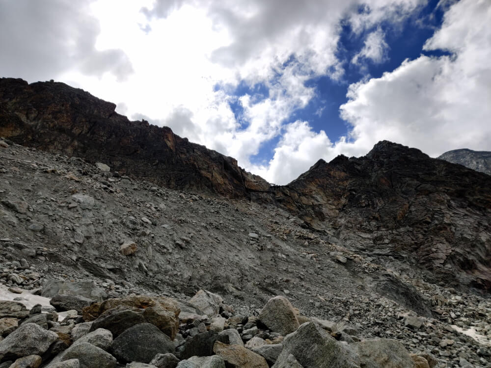
Pas de Chevres: A challenging section of the Haute Route. The trail leads left (beyond the edge of this image) then traverses along the top of the rockfall zone to the base of the ladders for the final climb right of centre.
I posted this update on the Haute Route Hiking Instagram/Facebook pages on the 3rd of August and invited hikers to give their perspectives on the conditions. Based on the range of views shared, you can see that each hiker will have a different perspective on whether this section is now too difficult or dangerous to complete.
The fact of the matter is that this section of trail is through a rock slide zone which has no infrastructure in place to protect hikers. Even though there are many people still passing through here, each hiker should determine if completing this section is the right call for them based on their risk appetite.
[Image Right] Challenging Section: Some hikers have been seen using rope to assist and others witnessed a hiker freezing part way up which had to be rescued by mountain guides. Pic courtesy of @daniellezanetto
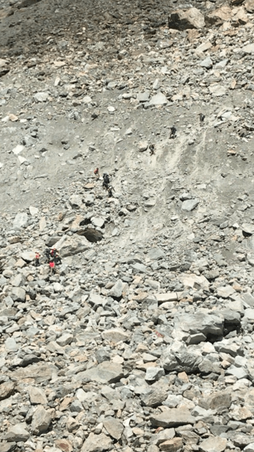
There is limited mitigation available to lower this risk - passing quickly (and carefully) through the rock slide zone and being conscious not to kick rocks on people below you, watching for animals or people doing this to you above can help. However, there is nothing you can do if a rockslide naturally occurs while you are in the fall zone.
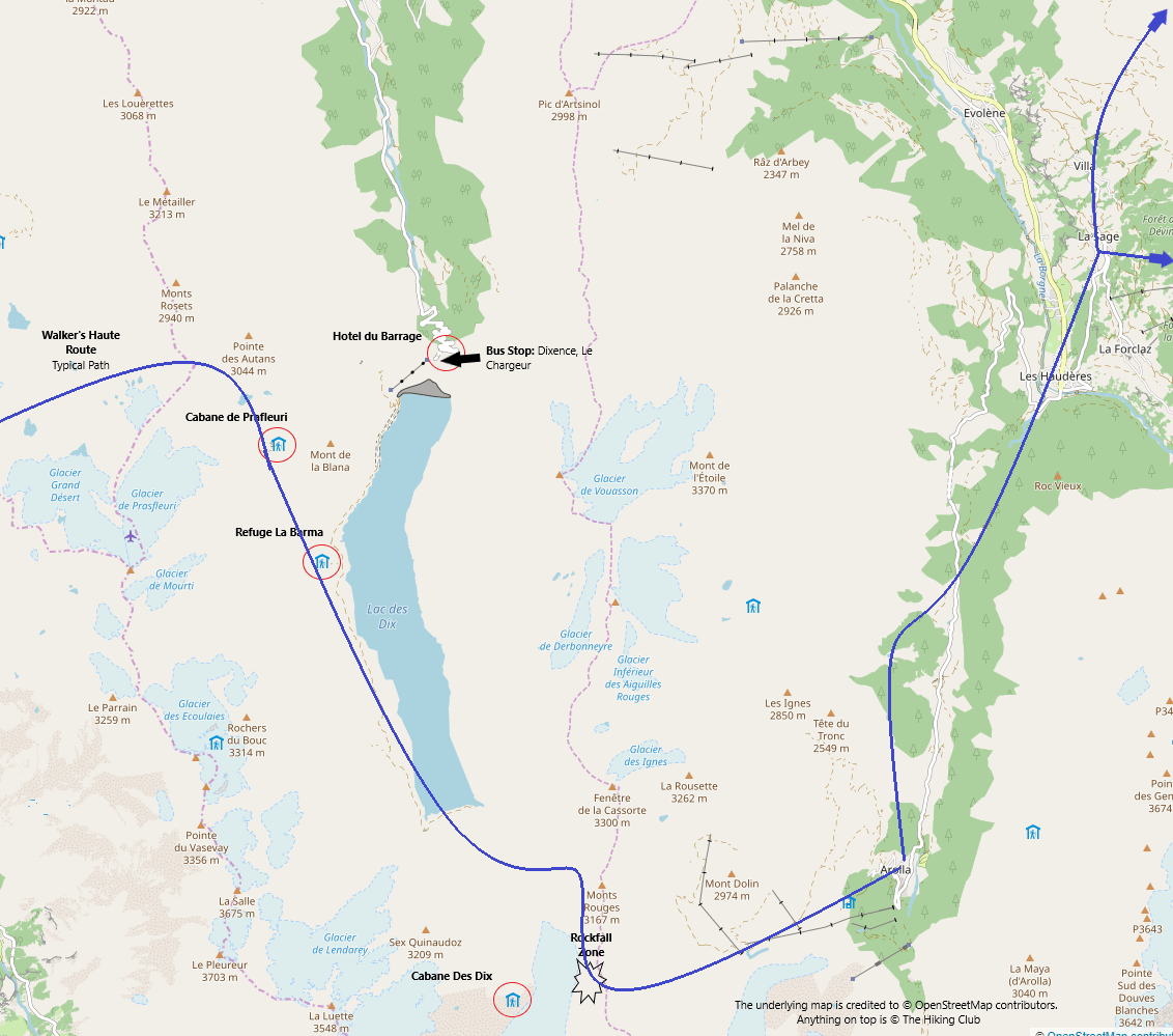
Rockfall zone: The section of trail through the rockfall zone to Pas de Chevres ladders/Col de Riedmatten is at the bottom centre of the image.
I expect that most people embarking on this multi-day hike have spent enough time in the mountains to have seen these types of higher risk trail sections before. I’d invite you to read the comments on the social media posts to determine what the right decision is for you.

Pas de Chevres: Red line highlights the approximate path to reach the base of the ladders.
what are your options if you don’t want to complete this section?
Don’t despair! There are plenty of other things you could do to make the most of this day :)
Option 1: Sleep in and rest your body
Hiking through the Grand Desert will be the most challenging day yet, particularly for hikers that choose the Bovine route instead of the Fentre pass. If you’re looking for an opportunity to rest your body and let blisters heal, have a little sleep in (first bus is at 10.30am!) then go to the bus stop at Dixence and catch a series of buses to reach Arolla/your next accommodation location.

Bus Connections: There are only a few buses that depart Grand Dixence each day and 2 with connections to Arolla. Check SBB website for details

Option 1: Take a rest day on the Walker’s Haute Route and transfer to your next destination via public transport
The bus stop is called ‘Dixence, Le Chargeur’ and located right outside Hotel du Barrage. The trail stats to reach the bus stop from nearby accommodation location;
Refuge La Barma > Dixence
Distance: 3.75 km (2.5 mi)
Elevation loss: 300 m (1,000 ft)
Estimated hiking time for average hiker: 1 hour
Cabane de Prafleuri > Dixence
Distance: 3.25 km (2 mi)
Elevation gain: 100m (330 ft)
Elevation loss: 600 m (2,000 ft)
Estimated hiking time for average hiker: 1 hour
Option 2: Skip ahead and climb to Pas de Chevres from the Arolla side
If you know you don’t want to do this section but you do want to see the area you’ve detoured, catch the buses to Arolla, drop you bag (or most of your weight) at your accommodation and hike up to Pas de Chevres. If climbing the ladders was something you wanted to do, you can even do this too given they are clear of the rockslide zone!

Option 2: Transfer to Arolla and hike up to Pas de Chevres to see the area you’ve detoured
Please note that the earliest time you can reach Arolla via public bus connections is 2.05pm. Cabane de Prafleuri/Hotel du Barrage will be able to arrange you a taxi/private transfer from Dixence to Arolla for 180 - 200 CHF for up to 7 people which is cheaper than the cost of catching the bus (CHF 30.60 pp) and will allow you to complete the trip in under 1 hour. Find other people at dinner who have the same plan as you and share the transfer with them!
Provided there are no afternoon storms forecast, there will still be enough time to reach Pas de Chevres and come back down to Arolla. The trail stats for this section;
Arolla > Pas de Chevres (Return)
Distance: 10.5 km (6.5 mi)
Elevation gain: 850 m (2,800 ft)
Elevation loss: 850 m (2,800 ft)
Estimated hiking time for average hiker: 4 hrs (so up to 5 hours with breaks/enjoying the top)
Option 3: Complete a tour of Val Des Dix then catch bus(es) to Arolla/your next accommodation location
This option won’t be for everyone. You’ll need to be capable of hiking 23-26.5 km (14-16.5 mi) within a set time frame to ensure you meet the last bus departing Grand Dixence OR be willing to pay for/found others to share a taxi/private transfer from Dixence to Arolla (180 - 200 CHF for up to 7 people).
For those that are undecided whether you’ll complete the section through the rockslide zone, keep this in mind because your plan b to stay on track will be making it back to Grand Dixence for the last bus/private transfer. If this sounds like you, read on to see what it’s going to take to still experience Val Des Dix without crossing Pas de Chevres.

Option 3: Follow your planned route along Lac Des Dix, up to the Cabane then across the Cheilon glacier before heading for the bus stop at Grand Dixence.
The trail stats are from each of the 3 accommodation locations you’re likely to be staying at;
Hotel du Barrage at Dixence > Cabane des Dix (return)
Distance: 26.5 km (16.5 mi)
Elevation gain: 1,050 m (3,400 ft)
Elevation loss: 1,550 m (5,100 ft)
Estimated hiking time for average hiker: 8.25 hrs + breaks
Cabane de Prafleuri > Cabane des Dix > Dixence
Distance: 26.5 km (16.5 mi)
Elevation gain: 975 m (3,200 ft)
Elevation loss: 1,425 m (4,675 ft)
Estimated hiking time for average hiker: 8.25 hrs + breaks
Refuge La Barma > Cabane des Dix > Dixence
Distance: 23 km (14.25 mi)
Elevation gain: 900 m (2,950 ft)
Elevation loss: 1,200 m (3,950 ft)
Estimated hiking time for average hiker: 7.25 hrs + breaks

Val Des Dix: Pas de Chevres in the low part of the range on the left, the tail of the Cheilon Glacier that hikers cross in the centre and Cabane Des Dix perched up on the right hand side
If you’re planning to catch the last bus, you’ll need to get an early start (probably 6am departure) to give yourself enough time to achieve this plan. You’ll be able to remove about 30 mins of hiking if you catch the cable car from the top of the Dixence dam wall to the bottom. Unfortunately, it doesn’t start running until 9.30am so don’t count on using it to shortcut anytime in the morning.
If you’ve stayed at Cabane Des Dix, it will take a little over 4 hours to reach the bus stop at Dixence via the Cheilon glacier.
Option 4: Hike an alternative route to Evolene then catch a bus to Arolla/your accommodation
If you’d like to continue hiking as far as possible and limit your transfer time, hiking an alternative route over Col de la Meina to Evoléne is the option for you.

Option 4: Hike to/from Hotel du Barrage, follow the trail up to Col de la Meina then down to Evolene where you can catch a bus up the valley to Arolla
The trail stats for this alternative route;
Distance: 17.25 km (10.75 mi)
Elevation gain: 950 m (3,100 ft)
Elevation loss: 1,675 m (5,500 ft)
Estimated hiking time for average hiker: 6 hrs (so up to 7.5 hours with breaks/enjoying the top)
If you’d like to reduce the distance and descent for this alternative route, you can catch the Chemeuille chairlift on the way down to Evolene which removes 4 km (2.5 mi) and just over 750m (2,500 ft) from the above trail stats. It costs CHF 10 pp one-way and runs until the September 15th from 9:00 to 13:15 / 14:15 to 16:30
From Evolene, there are a few more buses available to reach Arolla. All of them connect in Les Haudéres and go past La Gouille.

Bus Connections: The bus connections from Evoléne to Arolla are cheaper (CHF 9.80 pp), more frequent and have shorter transfer times than from Dixence. Check SBB website for details
How to decide what you’ll do
There are 3 key questions you need to answer;
Are you physically capable of traversing a steep section of loose rocks?
Do you have the composure to complete a challenging section without freezing or having a lasting negative effect?
Are you comfortable with the risk that comes with hiking through a rockfall zone that has recently been active?
By providing detailed information, inviting a range of views on social media and providing alternative options, I hope each hiker can answer these questions to reach their own conclusion on what’s best to do. After all, making these types of important decisions is empowering and demonstrates you are in control of own your journey…a key benefit of self-guided hiking!
Trail Closures
Cabane de Prafleuri to DixencE (Hotel du Barrage)
The high section of trail is officially closed between Cabane de Prafleuri and Dixence (Hotel du Barrage) due to some rocks falling across the trail.
Some hikers are still taking the high route because the trail isn’t actually blocked and it isn’t completely obvious on the Cabane de Prafleuri side that it’s closed. There is an alternative route which adds about 30min by going down the river and back up again - probably not what you want to hear after coming through the Grand Desert :)

Europaweg
Grachen to Europahutte (Europa Hut)
The section of trail between Grat and Galenburg remains closed. At this stage, it is believed that this trail may never be reopened due to the high avalanche risk in the area. Work has been done to the Grachen > Herbriggen > Galenburg section of trail to improve the signage and markings which will remain the main Europaweg detour route until further notice.
You can read my other blog post on the different detour options you have here

Suspension Bridge to Tashalp
Charles Kuonen suspension bridge: The Europaweg trail is open from the bridge to Zermatt
At the start of the summer, a couple of boulders came down which crossed but did not block the Europaweg trail just past the Charles Kuonen suspension bridge. Maintenance crews closed the trail while they assessed the area and put more infrastructure in place to protect the trail. This area of trail was reopened in July and hikers can freely follow the Europaweg all the way to Zermatt.

Minor Route Changes
For those using my GPS mobile maps, there are 3 more minor route changes I’d like to share with you. All of them are within 100 m (few hundred feet) of the trail I’ve marked so no need to add extra hiking time to your estimates. Thank you to @scvawser, @audreybenjamin, @chasingthesummits, Ted H and Kristen J for bringing these to my attention.
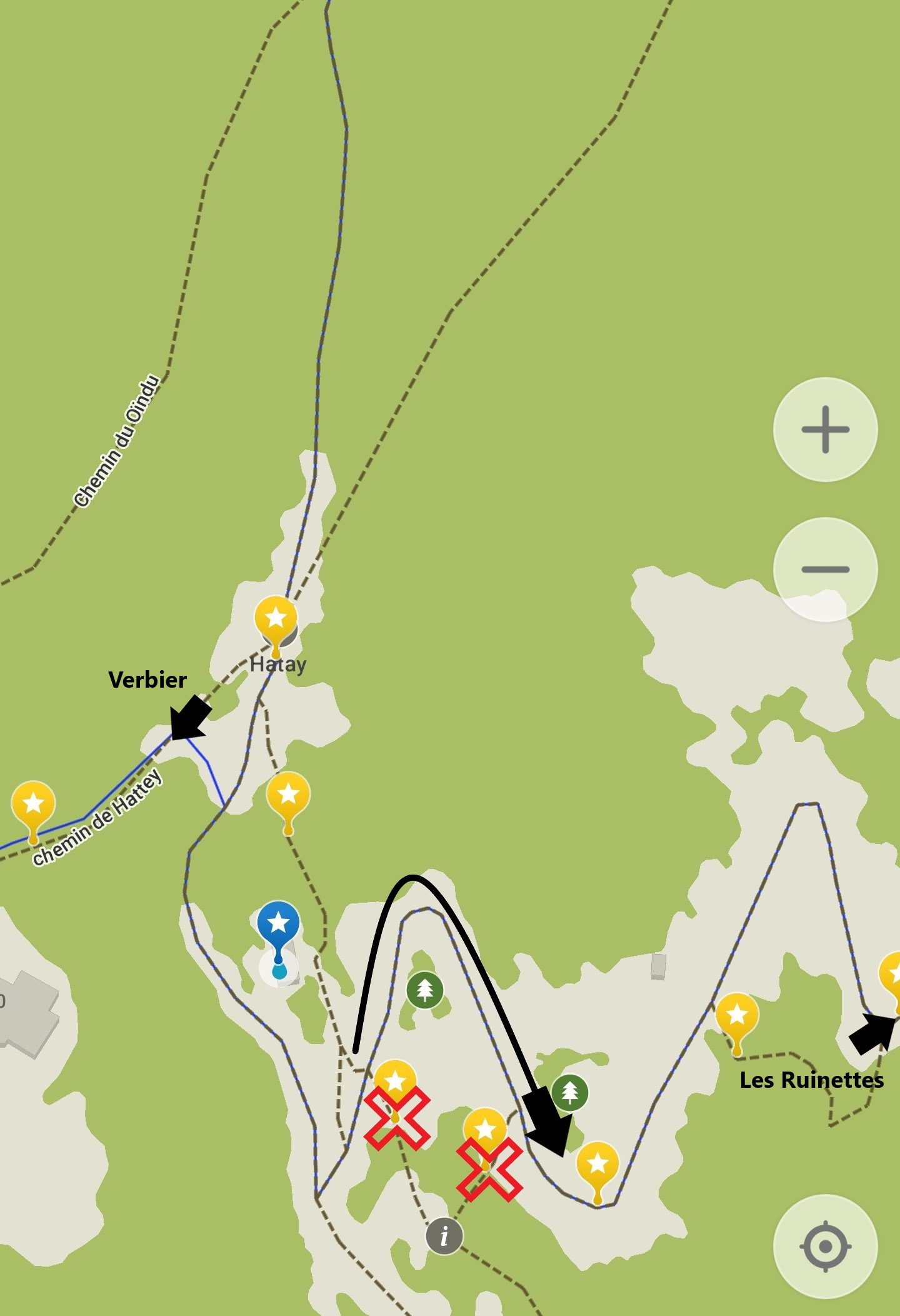
1. Verbier to Les Ruinettes
The marked trail is overgrown and some hikers have reported being stung by sting nettles when taking this path! As you come through Le Hattey, stick to the track instead taking the trail shortcuts and save yourself some itchy ankles :)
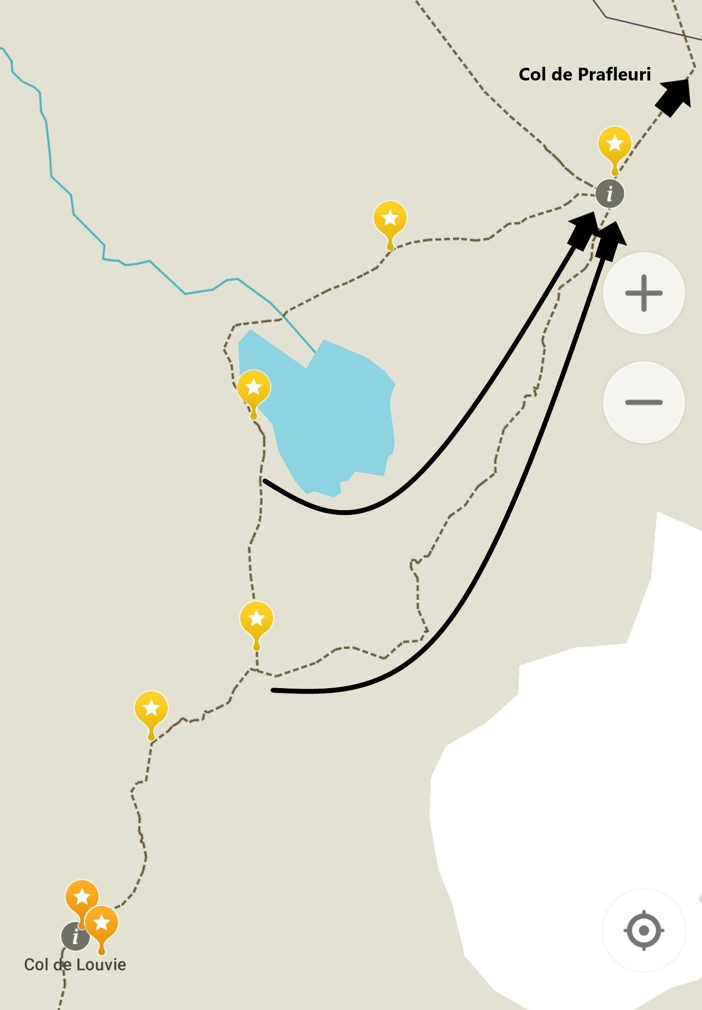
2. Grand Desert
There are new trail markers that direct hikers to the right side of the small lake. This is possibly due to the stream rising above the stones that you need to hop over if you take the left side. There are two opportunities to take the right side track as I’ve pointed out below - you can’t miss it! No matter which route you take, aim for the big boulder that is the main trail junction in the Grand Desert.
3. Forcletta to Gruben
As you near Gruben, you’ll start following a track. After making a hairpin turn to the right, the track continues on for about 1.2 km (0.7mi). The trail markers indicate you should take a left turn about 200 m (650 ft) after making this hairpin turn, however, this path is not longer in use. The trail you need to take peels off to the left at the hairpin turn and quickly joins up with the trail markers on the map to continue the descent to Gruben. If you miss this turnoff and continue on the track, you’ll end up adding about 20 min of hiking to your planned route.

Found any more issues with your map? Let me know at info@thehiking.club
Remember there were a few other minor changes I shared in the July Update too.
Walker's Haute Route Trail Updates
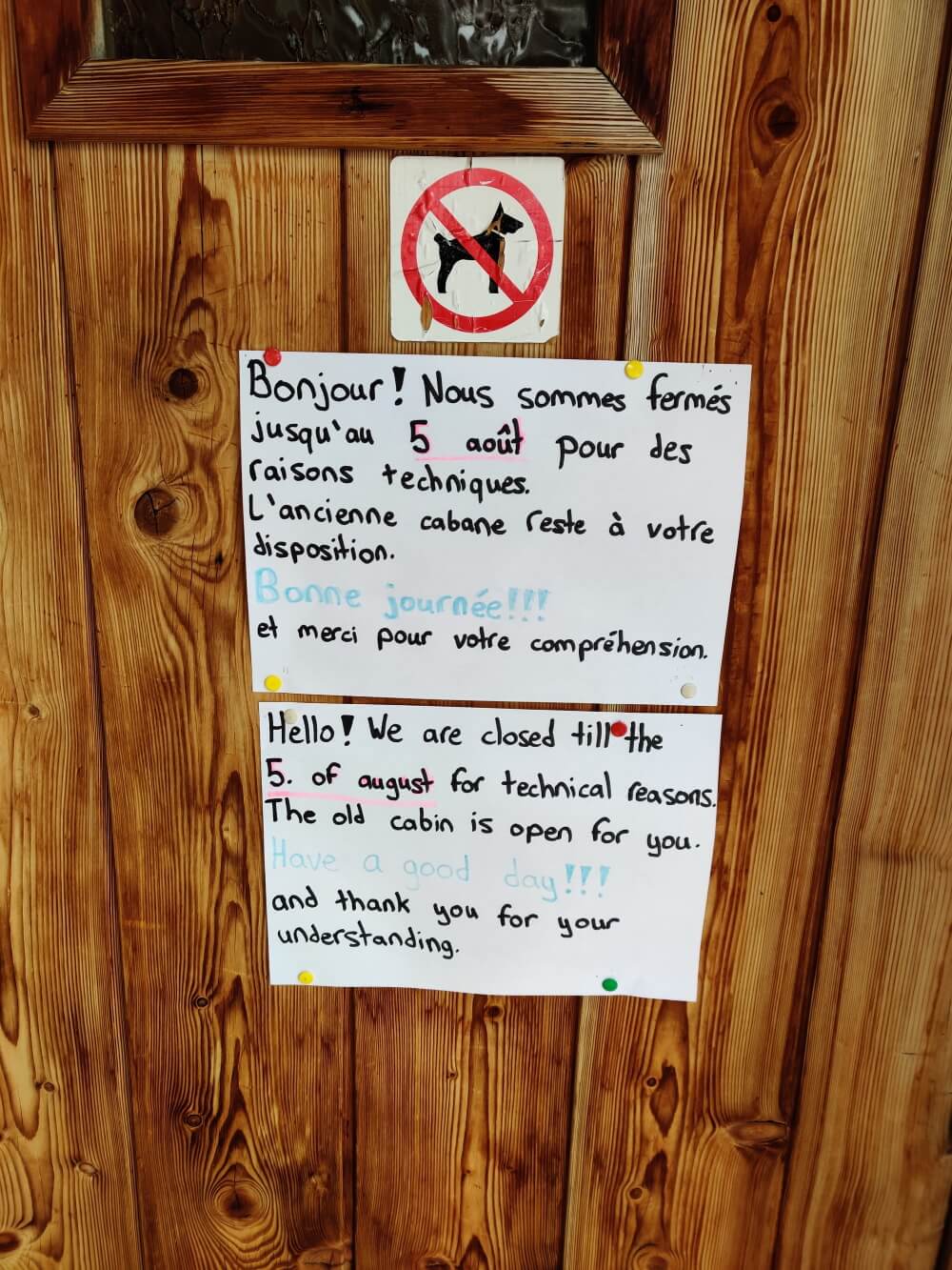
Cabane de Prafleuri has reopened
After 3 weeks of pest control and cleaning, Cabane de Prafleuri officially reopened on the 5th of August.
As there is no wifi at the Cabane, bookings, confirmations and any changes can be made by calling the cabane at +41 27 281 17 80
Hiking Time Estimate changes
I’ve received a range of feedback on how hikers are going compared with the time estimates for each trail section. While most hikers are typically meeting or beating the estimates, there are a few sections that they are falling behind. There are also some hikers that are consistently coming in well behind the estimates. I’ve been looking into whether hikers have overestimated their hiking speed/abilities or if there are changes in the estimate model that need to be made. Currently, I believe it is bit of both.
Most Hikers - Changes in Time Estimates
The only group that these increases in estimates don’t apply to are those Elite hikers that spend a lot of time on high alpine trails. This group has the fitness and confidence to absorb any time lost during sections of challenging terrain and their performance isn’t impacted at high altitudes (below 3,000m (9,850ft). For the rest of us mere mortals, read on!
1. Estimates are for hiking time only
Some hikers have been unsure if the estimates include breaks. They don’t. Breaks vary by hiker so I’ve not factored these in so you’ll need to add these on.
Additional Time Suggested: 1-2 hours per day depending on how you like your breaks
2. Estimates do not adequately account for challenging terrain
Following trail markers through a boulder field is slower then motoring along on a normal mountain trail.
Additional Time Suggested:
Fentre d’Arpette - Add 45 min
Col de la Chaux - Add 30 min
Col Termin/Cabane de Louvie to Col du Louvie - Add 15 min
Grand Desert - Add 45min
Pas de Chevres - Add 30 min
Augstbordpass to Jungen - Add 15 min
Suspension Bridge to Taschalp - add 30 min
Hikers have also reported going slower across the Cheilon glacier. This is mainly due to soaking up the experience rather than challenges with the terrain. I would suggest adding 30 min to your time estimate for this.

3. Estimates do not account for hikers coming from sea level
No matter your fitness at sea-level, the first couple of times you reach the higher altitude parts of the trail, it will take the wind out of your sails and slow you down. Time estimates already have incorporated a speed reduction for all trail above 2,400m (7,875 ft) which is the point where human performance starts to become materially impacted, however, most hikers report going much slower on the first couple of passes. Hikers living at or having already spent time at a higher altitude before starting the Haute Route can ignore this change, however, most will be impacted.
Additional Time Suggested:
Fentre d’Arpette Pass - Add 45 min
Grand Desert - Add 45 min
Hiker Specific - Changes in Time Estimates
There have been factors that are hiker specific. I don’t have enough information at this stage to recommend what an appropriate increase would be for each factor. I would suggest using your first couple of days (or whenever these factors emerge) to identify any differences in time estimates and apply your own increase to the remaining days if necessary.
Pack Weight: Unless you’re a thoroughbred, the heavier your pack, the less likely you are to achieve the time estimates.
Micro Breaks: When I hike, I stop and start the activity tracker on my Garmin watch to remove breaks for lunch, snacks, etc. However, I’ve noticed that my moving time is usually 85% of my hiking time. I call these my microbreaks which I take for chats, photos, sips, layer changes and moments to soak up the stunning surroundings. At the time, I don’t consider them worth stopping my watch but they end up adding up.
Blisters: Those who develop blisters will slow down as they manage these pain points.
Confidence in Challenging Terrain: As I mentioned above, challenging terrain slows most people down. However, depending on your confidence and agility, your speed may be reduced more than most people. For someone that is nervous crossing boulders or traversing a balcony trail, adding additional time for these sections may be necessary.
Knackered Knees: Unless you’re superhuman, your knees are going to feel sore at different points on the Haute Route! However, some hikers knees are more sensitive to descending trail than others and as a consequence, will always have reduced speed when hiking down.
What am I doing for 2020 Haute Route Hikers?
Thank you to everyone that has sent in their hiking times vs estimates so far. I’ll be sending out a survey to capture more specific data from everyone at the end of the 2019 hiking season. This information will be anonymous and used to provide better estimates in 2020 hikers based on additional factors.
Trivial Haute Route Pursuit
If you thought the physical challenge of climbing 11 mountain passes was the biggest challenge of the Haute Route, you were wrong!

We’ve built a game for our 2019 Haute Route hikers which combines Trivia, Puzzles and Quiz questions into one epic pursuit. This game is meant to:
Teach you about local people and culture
Test out your memory and math
Distract your mind from your sore legs each night or on the trail
Most importantly, have some fun!
HOW DOES THE GAME WORK?
There are 10 questions that you will need to solve in order to unlock the prize in Zermatt. These questions cover a variety of categories such as Geography, Arts & Literature, and of course Sports & Leisure.
In the latest update we emailed you, in addition to the awesome product enhancements, we snuck in 10 quiz questions into your map - surprise! If you open up your mobile map on maps.me, the quiz questions are disguised as orange markers throughout your Haute Route journey. See the image to the right for an example; Question 1: The Fondue Conspiracy.
It doesn’t matter if you bought a basic, complete or custom package, we’ve been able to sneak in the quiz questions to all of your mobile maps!

IS THERE A PRIZE?
Of course! For those hikers that manage to correctly solve all questions, we’ve arranged a special prize in Zermatt to help your celebrate your accomplishment at the finish line.
Will you see me on the trail?
I hope so! I’ve been exploring trails connected to the classic Haute Route over the last few weeks which includes new glacier crossings, via ferrata sections, easier mountain passes and more challenging alpine trails. My goal is to open up new options for future Haute Route hikers to choose their own unique route between Mont Blanc and the Matterhorn that better aligns with their trail and adventure preferences. After all, The Haute Route is the journey between these two iconic mountains, not a specific trail.
I’m planning another 4 week hiking block throughout the end of August/September so follow @hauteroutehiking on Instagram/Facebook to see when I’ll be crossing over the Haute Route. You can also follow @thehikingclub to see how I’m unlocking the Alps by taking the adventure beyond the guidebook to connect the Haute Route with the Tour du Mont Blanc, Tour of Monte Rosa, Tour of Matterhorn/Cervina, Tour of Grand Combine and AV1 Aosta Valley.

Walker’s Haute Route 2020: New routes and highlights will be added to the platform that will provide more choice in adventure and trail preferences
Final Word
Thank you to all the hikers sending in updates to help those coming after you.
I continue to freely pass on any information received in order to help others navigate the trail challenges during their Haute Route hike.
This will be the last 2019 season update unless there is a material change to the trail that hikers need to be aware of.
Stay safe and enjoy the adventure!
Brendan
