

Sam McGrady and Steve Smedley live in Matlock, Derbyshire, and are seasoned multi-day trekkers across Europe and the UK. Focused on travelling as light as possible (no camping), they undertake at least one long-ish trek each summer using mountain huts and small villages for accommodation. Previous trips have included Walkers’ Haute Route, GR11 (Spanish Pyrenees traverse), Tour de Mont Blanc, Tour de Monte Rosa and AV1 (Dolomites).

Summer 2024’s adventure took Sam and Steve back to Switzerland to undertake the Tour of Jungfrau Region (JFR) – which whilst following the ‘official’ route most of the time, they made their own with variants, side trips and some extra days thrown in. It should also be noted that Sam and Steve are vegetarians, so references to food should be taken in that context and explains the obsession with rostis on this trip!
Trip summary
13 hiking days
1 rest day (at Kleine Scheidegg)
Total distance – approximately 196 km (122 miles)
Total ascent/descent – 12,390m (40,650 ft) gain/loss
Start/finish – Wilderswil (Interlaken), Switzerland
General observations on the Tour of Jungfrau:
It’s very popular and busy – not so much the trail itself but there are lots of very accessible points most days via an excellent integrated public transport system (trains, cable cars, ski lifts, buses) resulting in hoards of ‘tourists’. It’s not a trek for getting away from it all.
The walking is straight forward, nothing technical. Likewise route finding simply isn’t an issue. The amount and variety of accommodation options mean you can make your days as long or short as you want. Don’t feel the need to stick to the traditional route and stages, busk around the template.
It is an area of outstanding and amazing scenery – Eiger, Monch and Jungfrau are omnipresent and undoubtedly the star attraction, but this should not diminish the contribution of many other outstanding mountains that will be familiar to alpinists but not the average hiker or tourist. There are also numerous glaciers to see and the landscape is varied and interesting. When we went the alpine flowers were abundant and a joy to see. Take your time, stop and stare.
TOUR OF JUNGFRAU LAUNCHING SOON
Day 1 (3 July) – Interlaken to Breitlauennen station
9km, 1076m up, 2 hours 40 mins
Having flown to Geneva and then taken a train to Interlaken the previous day, we started our TJR with a great breakfast in the Alphorn hotel in Interlaken, including fresh fruit and hard boiled eggs. We walked across the Ruegen to Wilderswil (a lovely village in contrast to the somewhat tourist-hammered Interlaken) then set off walking uphill through forest to the cog railway station at Breitlauenen, which has a fab little café.
As the onward path to Schynige Platte was closed due to rockfall we took the cog railway for the remaining relatively short distance – which was fun! After checking in to the somewhat swanky Berghotel Schynige Platte (the only show in town) the cloud was down and the rain had started. As we’d reached our destination for the day this wasn’t a problem and we had a decent meal in the hotel looking out at cloud and rain where one of the best views in Switzerland should have been!

Panorama Schynige Platte to Grosse Scheidegg
Day 2 (4 July) – Schynige Platte to Grosse Scheidegg via Faulhorn
24km, 1200m up, 6.25 hours
We woke up to completely clear skies, sun and amazing views of the full mountain range opposite – Eiger, Monch and Jungfrau, which would accompany us on much of this trek. After a great breakfast of eggs, cheese and local honeycomb, we packed up and set off, taking our time for the first few miles to stare and take photos.
Spring flowers were abundant. The weather was sunny but with a fresh cool wind. The route took us across myriad snowfields which really slowed us down. However, we had absolutely amazing views all the way – Eiger, Monch and Jungfrau to the right and Brienzsee below us to the left - and even saw an eagle near the Faulhorn (today’s high point).

Views all the way – Eiger, Monch and Jungfrau
The route wasn’t too busy until we reached the Bachsee lakes, which were teeming with visitors who had come up on the gondola to First. We were happy to leave the selfie-fest behind at First (the official end of today’s stage but not our end point) and took a solitary walk to Grosse Scheidegg in increasing cloud. What an amazing spot - right underneath the Wetterhorn.
Again, the Berghotel Grosse Scheidegg is the only accommodation here, and we had a cosy double room. The food was good: salad plus rosti with fried vegetables. After a long day we headed for an early night.

Wetterhorn above Grosse Scheidegg
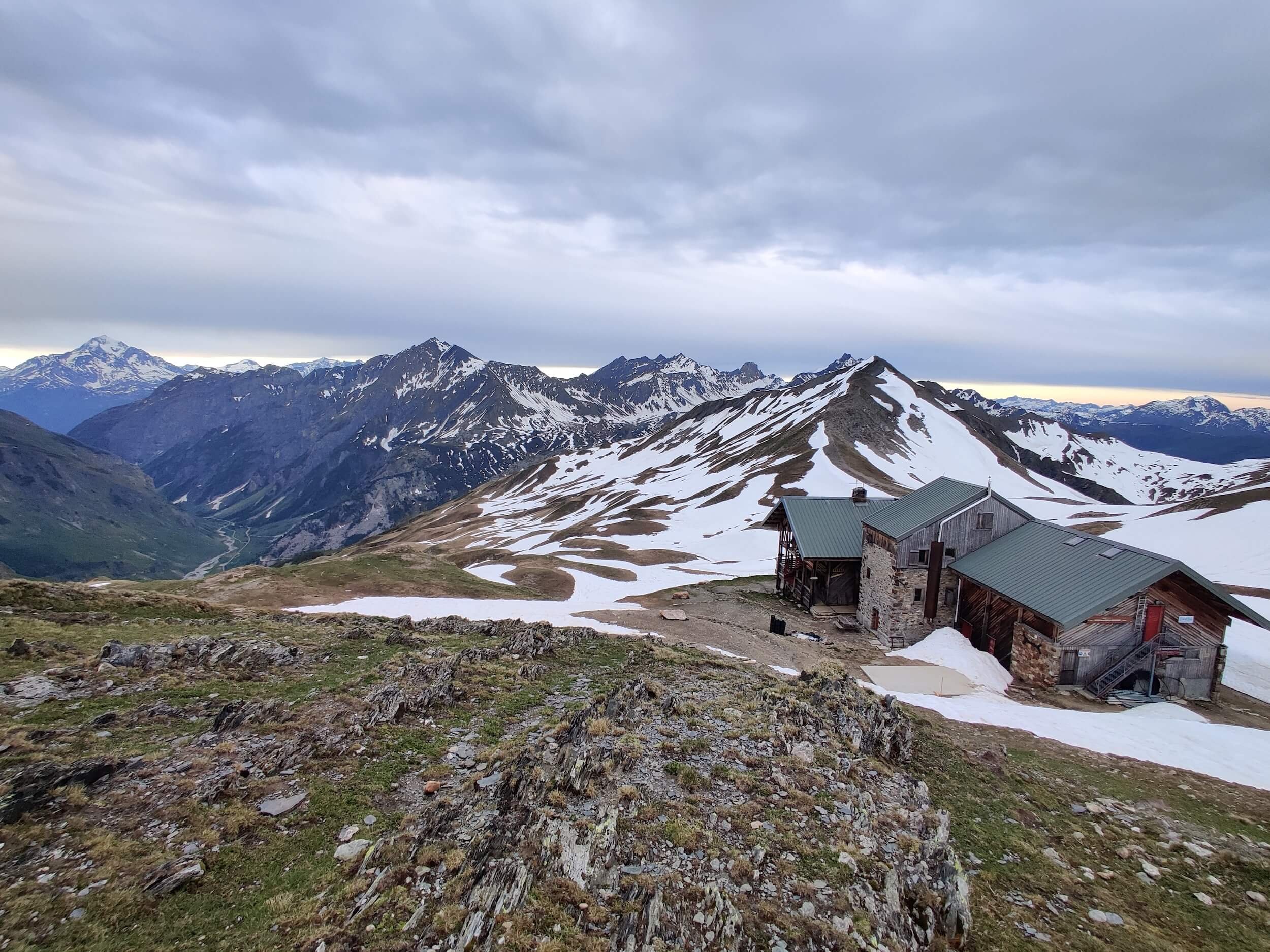
Day 3 (5 July) – Grosse Scheidegg to Hotel Wetterhorn via Gleckstein Hut
13km, 927m up, 4.5 hours
After a fairly basic breakfast, we headed off around 9.30am down the path towards Grindelwald. After about 30 minutes we went left on a TJR variant towards the Gleckstein Hut. The route comprised a somewhat vertiginous path a lot of the way with chains and cables – but all perfectly manageable. Up, up and up we went. Above us towered the Oberer Grindelwald Gletscher and beyond it the Schreckhorn; we also saw chamois, ravens and choughs.

View of glacier from Gleckstein Hut
All day we had full, hot sun, because whilst the substantive route is roughly east/west, the variant to the hut is north/south. The hut was in an amazing spot, and we drank coffee whilst watching ice falls from glacier – we could have stayed all afternoon!
After a slice of delicious nusskuchen, we headed back down the same way we came, which was hard on ageing knees and our walking poles were required. We stopped for a snack at possibly the most exposed bench in the valley before re-crossing a short snowfield then heading across meadows to Hotel Wetterhorn near Grindelwald.
We sat outside with a beer and looked up at the knife edge Mittellegi ridge of the Eiger right above us. Our evening meal comprised another rosti (this time with egg and cheese) and a savoury vegetable strudel. A wonderful spot to end the day.

Most exposed bench in Grindelwald valley!
Day 4 (6 July) – Hotel Wetterhorn to Alpiglen via Berggasthaus Baregg
19km, 1475m up, 5.5 hours
After a decent breakfast of fresh fruit and muesli, we set off around 9am in the dry, although rain was forecast for later in the day. As it happened we spent most of the day in woods but we did get some short lived heavy rain in the afternoon, necessitating an outing of our waterproof ponchos!
Again, we decided to make a side trip off the TJR up and back to Berggasthaus Barregg to see another glacier – not such a big climb but an equally great spot where we had coffee, and a good chat with the hut guardian about how the previous month’s awful wet weather had taken a real toll on trade.
After a long descent back to the valley bottom, we climbed up all afternoon, eventually making it to Alpiglen. The route was excellent, right underneath the Eiger and we saw several chamois. Unfortunately the cloud was down most of the time so we couldn’t make the most of the location. However, on the short descent to Alpiglen itself the cloud broke up enough for us to have views right across the valley back to Schynige Platte. Once again we were in the only available accommodation in the hamlet.
In the evening we got chatting to some young American hikers who were doing some of the TJR but in the opposite direction; for a future trip they usefully put us onto the White Mountains in New Hampshire where they have a hut system similar to Europe.

Snowfield and sheep on way to Alpiglen
Day 5 (7 July) – Alpiglen to Kleine Scheidegg
9km, 852m up, 2.5 hours
Hotel Alpiglen provided a good breakfast with fruit, yogurt, muesli, bread and cheese; we strung it out due to 100% cloud cover and light rain, and so didn’t leave till gone 10am. Climbing up we crossed numerous torrents and small snow fields, and saw two alpine salamanders which seemed unaware of Darwinian evolutionary theory and slowly meandered around our feet.
The cloud lifted a little from time to time but it was very frustrating that we were right underneath the Eiger north wall and couldn’t see it! The rain stopped around midday but we were still plagued with poor visibility. We stopped at Eigergletscher (gondola and train station) for coffee and Rahmschnitte cake (a local speciality, great for morale but bad for the abs!).
From here it was an easy half hour down to Kleine Scheidegg, conditions were cool and cloudy. After checking into our accommodation at Restaurant Grindelwaldblick we did some laundry and booked tickets for the Jungfraujoch for tomorrow – our first rest day. The cloud was still down so we had yet to see the infamous Eiger North Face properly. To celebrate making it this far we ordered a cheese fondue which was delicious! It is worth noting that when the cloud clears, this location has one of the best views of Eiger, Monch and Jungfrau due it standing half a kilometre or so back from Kleine Scheidegg itself.

Eiger North Face emerges from cloud
8 July – rest day to jungfraujoch
though we still managed to walk an unofficial 9.5km!
We got up at 7am to try to get the early bird train to Jungfraujoch (the amazing railway which goes through the middle of the Eiger and pops out at the saddle between Monch and Jungfrau, where there is a huge visitor centre). There was an enormous number of tourists, and we had to queue and so didn’t get the first train; it’s definitely worth paying the extra to reserve a seat in advance. In fact the whole thing was unbelievably busy all day. However, it was an exciting train journey up through the tunnel, and we headed straight out into the snow and walked to the Monchsjochhutte for coffee and plum tart. This was our only use of our micro spikes on the whole trip.
After a quick look round the tourist attractions at the centre (not really our thing), we took the train down to Eigergletscher and then walked back along part of yesterday’s route to the foot of the Eiger which came out of the cloud at last, and we were delighted to spot the train Eigerwand windows. After an afternoon’s rest we ate at our hotel again then went outside to stare at the Eigernordwand.
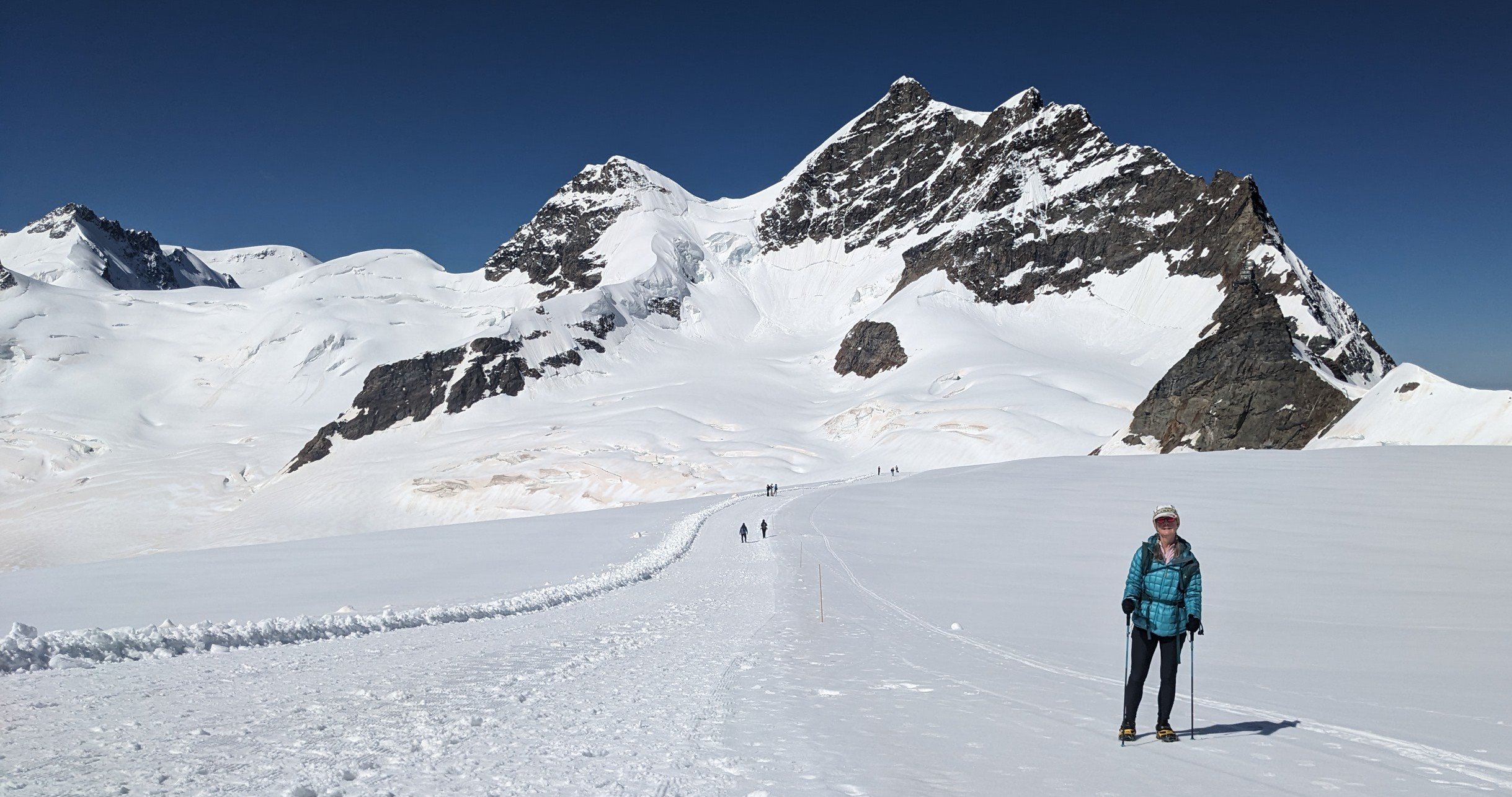
Between Jungfraujoch and Monchsjochhutte
Day 6 (10 July) – Kleine Scheidegg to Murren via Stechelberg
23km, 1005m up, 6 hours
After our day off (in which we still did two short walks!), this was a long day and our feet felt a bit pounded by the end, not least because it was very hot all day. The route took us down what became quite a tough descent close to the foot of the Jungfrau with excellent views of its pyramidal sub-peak, the Silberhorn, to the Trummelbach Falls, followed by a few welcome flat kilometers along the valley bottom to Stechelberg. Officially, this day’s stage ends here, but we had been unable to book accommodation at either of the two berghotels in the village, and so we ended the afternoon with a hot ascent to Murren (and as a result were once again ‘off’ the official TJR route). No-one else was ascending – they had all gone up in the gondola and were sauntering back down!
Today took us from the Grindelwald into the Lauterbrunnen valley, which was interesting in itself, and we also noted this was the lowest altitude we’d been at for a week; it felt different and gave us a better sense of just how high the mountains here are, as we were so far below them. After a welcome shower at our hotel (Hotel Jungfrau Murren) and a beer, we ate another rosti at Hotel Alpina which had amazing views across the valley.

Lauterbrunnen valley looking towards Breithorn and Tschingelhorn
Day 7 (11 July) – Murren to Berggasthaus Tschingelhorn via Tanzbodeli
10.5km, 955m up, 3.25 hours
Murren was noticeably quieter this morning, the gondola and train having yet to start running! After another lovely Swiss breakfast of scrambled egg, cheese, fresh fruit and seeded bread, we set off down to Gimmelwald via the Co-op (to stock up on peanuts and dried apricots), one of the few shops on our trek. We were heading back onto the official TJR route, but doing this and the next stage in the opposite direction due to our starting and end points. We headed down to Im Tal, crossed the river then walked steeply uphill in woodland for over two hours to Tanzbodeli, a flower-filled plateau.
After early light rain showers the cloud lifted and the sun came out. We descended from the plateau and contoured to Obersteinberg for a beer. Not much fancying a night of cold showers and no electricity (apparently these are ‘attractions’ of Berggasthaus Obersteinberg!), we headed 15 minutes down the valley to Berggasthaus Tschingelhorn, where we had a lovely wooden room with a balcony and chairs. We took advantage of a shorter day and rested our tired legs, planning our onward route as our plans to get up to the Schilthorn were well and truly scotched by a combination of not being able to get a bed at the Rostock Hut along with rain and low cloud forecast.
We have a rule about not going up a mountain for the sake of ticking it off: what is the point of doing it if you can’t see anything, particularly if the weather is going to be miserable. The evening meal was tasty (Thai soup, falafels and pasta) which we ate watching goats play outside.

On the Tanzbodeli
Day 8 (12 July) – Berggasthaus Tschingelhorn to Gimmelwald via Oberhornsee, Schmadri Hut and Trachsellauenen
16.5km, 1036m up, 5 hours 20 mins
Today was a great route, taking us high up into the Oberhornsee hanging valley, though it felt like a longer day than it was! An easy longish ascent brought us to the small lake: Oberhornsee, which was beautiful and we spent a long time looking at the mountains being reflected in it and taking photos.
There were a few people on the trail but not many; much of today felt more remote than some of the other stages due to the lack of transport to bring tourists up here, to what is effectively the head of the Lauterbrunnen valley. After a short out and back to the Schmadri Hut (unmanned – we just went for the extra ascent!), we headed down some tricky terrain which slowed us down, along with hot and humid weather. We stopped for a refreshing cold drink and apricot tart at Trachsellauenen.
Our accommodation at the Mountain Hostel at Gimmelwald required yet another ascent at the end of the day, and we were pleased to have a beer and a surprisingly tasty pizza here. At one point the heavens opened and some very heavy rain came down. We slept well despite it being a hostel full of what seemed to us very young people!

Reflections in the Oberhornsee
Day 9 (13 JULY) – Gimmelwald to Blumental
5.6km, 610m up, 1.75 hours)
As above, weather and accommodation options put paid to us sticking to the TJR (which would have taken us up and over the Schilthorn) for the next few days, so we made up our own trek. Today we woke to overcast skies with heavy rain forecast, requiring a very short day. We embarked on a local route called the North Face Trail (nothing to do with the clothing brand!) which zigzagged above Gimmelwald and Murren and had information boards at regular points explaining ascents of the north faces of all the mountains opposite us.
Despite the cloudy day, it was (at this point) high cloud and gave us the best views so far of the high peaks opposite. We kept looking up at the Schilthorn above us and were tempted to give it a go, but stuck to our plans and headed straight to the Blumental and Pension Suppenalp. After some lunch we left our rucksacks and took a stroll over to the gondola station at Allmenhubel, but rain and cool winds drove us back; the cloud was down and we were satisfied with our decision not to attempt the Schilthorn in what would have been challenging conditions with no view. Sometimes the weather wins, At least we have an excuse to go back!

In the mist at Allmendhubel
Day 10 (14 JULY) – Blumental to Wengen via Lauterbrunnen
18km, 805m up, 4.75 hours
Today we were headed to Wengen where we’d decided to spend three nights so as to extend the TJR, to see some of the local walks not on the official route, and to cook our own veggie food. Our only objective was to reach Wengen. We headed off into low cloud and drizzle again, and saw only a few other walkers. Towards Grutschalp we took a continuation of the North Face trail which is effectively a balcony route high on the west side of the valley. We extended our walk beyond Grutschalp in the hope of better weather coming in, but as this didn’t happen we had a coffee at the gondola station and walked down to Lauterbrunnen.
The town was very busy so we didn’t linger and headed straight up to Wengen, a lovely village which seemed to be very busy at weekends but much quieter in the week. After checking into our self-catering somewhat bijou studio, we found a launderette and supermarket, then cooked bean, lentil and vegetable stew which we ate for the next three days – we needed a break from cheese and potatoes! The cloud stayed down all evening and it was noticeably cooler.

Looking down at Lauterbrunnen
Day 11 (15 JULY) – Wengen Mannlichen circuit
19km, 1280m up, 5 hours
Our first full day in Wengen turned out to be one of the best days on the whole TJR (even though it’s not on the TJR!), as the views from Mannlichen were amazing! From the top we could see the whole TJR route - both valleys and all the mountains. We were surprised that Mannlichen is only included as an optional side trip from Kleine Scheidegg on the official tour.
We took a very steep ascent up the Gemsweg (path of the chamois) to the gondola station just below the summit on what turned out to be a gorgeous sunny day with full visibility - apart from cloud stubbornly hanging on the Schilthorn! The summit was heaving with tourists, so after marvelling at the panoramic views of the TJR, we pressed on towards Kleine Scheidegg on a contouring route which was quite busy.
Before reaching the village, we headed up onto a higher contour around the summit of the Lauberhorn which was much quieter. The descent down a ski piste towards the Lauterbrunnen/Kleine Scheidegg railway line was steady but tough on the legs as it was sustained and lengthy. We stopped around 30 minutes short of Wengen at Allmend for a beer then headed back to Wengen, where we ate on our balcony looking at the outstanding view up to the Breithorn.

Panorama Grindelwald valley from Mannlichen
Day 12 (16 JULY) – Wengen Leiterhorn circuit
9.3km, 372m up, 2.25 hours
Having decided to treat today as a short/rest day, we did a local walk in lovely sunshine which took us up and along to Spatenenalp then back via the Leiterhorn viewpoint. This was useful as it gave us a good insight into tomorrow’s route (back up to Grutschalp, along and down to Wilderswil). The rest of the day comprised reading on the balcony, a short walk around the village, and culminated in a massive electric thunderstorm which we watched from the balcony around 7pm.

View from Spatenalp
Day 13 (17 JULY) – Wengen to Wilderswil via Grutschalp and Lobhorn Hut
19.3km, 793m up, 1690m down, 5 hours 40 mins
Our last day! Fortunately the weather was much better than anticipated but everything was very wet underfoot after last night’s rain. Most paths were mud or streams or super slippy wet limestone and tree roots. We walked down to Lauterbrunnen and decided to cut out around 1.5 hours of ascent (which we’d already done in the other direction) back up to Grutschalp by taking the gondola. From there, it was a really nice route contouring through trees which then opened up eventually to the Lobhorn Hut; we ate our lunch by the little lake there.
Onwards there was a little more ascent to cross a very stony corrie, the Tolkienesque Sylertal, where we followed a solitary chamois along the path. We finally began the long descent through woods all the way down to Wilderswil. Here we took the most direct route back to the village which zigzags north past the Schwarzhore rather than the official route via Saxeten. It was somewhat knee jarring and a bit mind bending – a good mental test! However, with hindsight we should have stuck to the suggested route as it probably offered a gentler and more interesting descent than the steep woods!
Towards the end we stopped at a memorial for 1998 flash flood disaster victims, which was sobering. After arriving at our final hotel (Hotel Edelweiss), a shower then a beer plus another fondue concluded our trek. Our legs were tired but as ever we were pleased we completed it and ready to eat anything but cheese!

Lunch spot on last day
Additional notes:
A note about the Eiger North Face and the train – the train passes the window in the north face where rescuers got tantalisingly close to rescuing poor Toni Kurz in 1936. Only 23 years old, he died just feet away from them, unable to abseil past a knot in his rope. The excellent documentary that tells Toni’s story (“The Beckoning Silence”) is essential preparation for staring in awe at the North Face and a sombre antidote to the ‘theme park’ at the Jungfraujoch.
To help understand the lay of the land, think of the TJR as being scruffily hung around a letter L which has rotated 90 degrees clockwise. West/east is the Grindelwald valley, south/north the Lauterbrunnen valley. The route in effect follows the skyline of these two. Mannlichen sits at the apex. It is almost too much to take in – which is why the TJR is so different from most linear long distance routes. Here, at Mannlichen, your entire trip is set out as a wonderful 360 degree panorama.